History
The word Kumai comes from the phrase “kembali ke pangkuanku”, in the Bugis language. It means “return to my lap”. Kumai was once part of the Kutaringin Monarchy. It was originally lead by Pangeran Bendahara, who later gave Kumai to Muhammad Cik, Kumai’s village leader. Cik then gave his position to Amsar, who was chosen to be regent of Kumai.
There are many historical places in Kumai. This is because it was a base for Indonesian fighters to attack the Dutch and also Japanese. The tragedy happened on January 14, 1946. Many warriors were killed there, but they could maintain their base. To commemorate the battle, the government has built a monument and a park there. The name of the park is “Taman Bahagia”. It is located in Sei. On Tendang and on every January 14, people celebrate in the park to remember Kumai’s warriors. The Kobar regent always attends.
Kumai District is the largest district in the West Kotawaringin regency, and is divided into three subdistricts, namely Kumai, Pangkalan Lada and Pangkalan Banteng. Those districts are about 4.456 km², and have been mutually agreed upon by the Local House of Representative (DPRD). The Regent at that time, H Abdul Razak signed the region regulation about the district forming in plenary meeting forum of council. The final result was a long process from various solutions with the first plan. The modification happened either from the name of district and opinion about Kumai which was intended by government to divide into four political districts plus one regional political district of coastal area.
In that plenary meeting, seven factions of council supporters had agreed and accepted the Raperda (Regional government meeting) dividing Kumai District into the specified Regions. "By saying ‘Bismillahirahmanirrahim’, we express to accept the Raperda become the Region regulation about regional forming of Pangkalan Lada district and Pangkalan Banteng, while Kumai as main district" said Sumanto, S.E, chief of Army Fraction of Republic Indonesia police. Regent of West Kotawaringin at that time, H Abdul Razak after signing the region regulation explained, the result of formula and agreement between regency government and DPRD have specified two new districts as a part of Kumai district. He said "By forming two new districts, we expect that it can support the public service in governance affairs, development issue and social affairs."
The capital of Pangkalan Lada district is Pandu Senjaya (ex Pangkalan Lada SP 4). The district is initially proposed as a Center for Kumai, covering seven counties, namely Makarti Jaya, Pangkalan Lada, Pandu Senjaya, Lada Mandala Jaya, Sumber Agung, Sungai Rangit Jaya and Purba Sari. Karang Mulya is the capital of Pangkalan Banteng District (ex Natai Kerbau SP 4). The easternmost initially is proposed by as East Kumai covering eight counties. These are Desa Mulya Jadi, Pangkalan Banteng, Karang Mulya, Marga Mulya, Arga Mulya, Amin Jaya, Sido Mulya and Kebun Agung. At that time, the Regent hoped, if two new districts could have the larger ones opportunity in existing exploiting the potency of resources.
The motto of Kumai is “Beriman” which is an acronym of Bersih (clean), Indah (beautiful), Ramah (sociable) dan Aman (peaceful). The motto itself literally is translated as “Religious”.
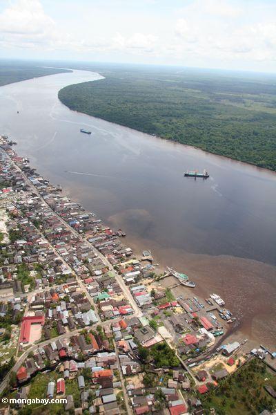
Kumai has total area about 2.921,00 km². On the north side, the Kumi is adjacent to the Arut Utara district. Seruyan regency is to the East, Java Sea to the South, and Arut Selatan to the West.
The capital of Kumai District is Kumai. It is divided into 3 sub districts and 14 regions. The sub districts are Kumai Hulu, Kumai Hilir and Candi and the regions are Sei. Cabang, Teluk Pulai, Sei. Sekonyer, Batu Belaman, Pangkalan Satu, Kubu, Sei. Bakau, Sei. Bedaun, Teluk Bogam, Keraya, Sebuai, Sei. Kapitan, and Bumiharjo.
 Ethnic backgrounds
Mosque: 33
Small Mosque: 83
Church: 3
Other: 1
Hadrah: a form of Islamic music which uses rebana.
Bebersih Benua or cleaning continent (refuse the disaster or bad luck) It is held in every year by fishermen.
Traditional ceremonies. The ceremonies are usually held in Kumai such as weddings, circumcision, etc.
Japin. A dance of the Melayu people. It can be found performed in the district of Candi. Rebana. This is a form of Islamic art that has been integrated into local culture.
 1. Tanjung Puting National Park Tanjung Puting National Park is a conservation area that provides a protected system of life. It protects a large variety of plants, animals and their associated ecosystems. It is the largest protected area of swamp forest in South-East Asia.
Tanjung Puting first received a level of protection in 1935 and was officially designated as a Wildlife Reserve in 1939. In 1982, it was declared a National Park.
The Park was established primarily for the protection of the Bornean Orangutan (Pongo pygmaeus), and its formation was instigated and aided by the efforts of Dr. Birute Galdikas and Orangutan Foundation International. When this area become a national park, Tanjung Harapan moved to the other side of the Sekonyer river (across the original area). The original width of the park was 300,040ha. In its new location, it increased to 415,040ha.
The Park receives aid from Orangutan International Canada and it is recognized as a World Biosphere Reserve by the United Nations. Tanjung Puting occupies most of the peninsula between Teluk Kumai and the Seruyan River and consists of varied habitats including peat and freshwater swamp forests, lowland tropical rainforests and heath forests. The Park is drained by several black water rivers emanating from the northern and eastern parts.
Tanjung Puting National Park is famous primarily because of two primates: the Orangutan and the Proboscis Monkey (endemic to Borneo). At Camp Leakey, research is conducted on Orangutans, Gibbons, other animals and ecological processes. Orangutans are also rehabilitated and returned to the wild from this Camp. Since 1971 over 200 Orangutans have been returned to the wild as part of Dr. Birute Galdika's Orangutan Research and Conservation Project.
The park is divided into 4 areas, each highlighting a different set of natural resources. They are:
a. TANJUNG HARAPAN. This area was developed for the ecotourism and hosts the information center, guest house, watcher tower and camping ground. By travelling along the edge of the river, you will see the nipah formation, screw pine and bog forest, and then you can do tracking and bird watching. We can enter to the center of TNTP information to get the information from the officer. We can stay in guest house. There are 3 rooms for 6 people and home stay are divided into 4 houses in Sekonyer countryside by 8 rooms for 16 people with reasonable ticket. You can buy the souvenir from TNTP that are typical souvenir like T-shirt, key hanger, sticker, painting of orangutan and orangutan statue.
b. PONDOK TANGGUI. This is a special place which representing the existence of pre-wild and adolescent Orangutan. It is host to various kinds of animals like deer, pig, rangkong bird (Rhinoceros), Raja Udang bird and Sesep Madu bird. During journeys from Tanjung Harapan to Pondok Tanggui, you pass through the habitats of the Bekantan Monkey and the Estuarine Crocodile (Crocodylus porosus dan Tomistoma schlegelli) along the journey.
c. CAMP LEAKEY. This area is devoted to the research and rehabilitation of adult Orangutan. It is suitable for visiting the place to see the Orangutan rehabilitation both for pre-wild or wild. Beside that, you can enjoy the Owa-owa, Bald Eagle, Sesep Madu bird, and Hornbill (Enggang) or Rangkong.
2. PANTAI SUNGAI CABANG.
This area is located alongside a white sand beach. The working and maintenance huts are located here, along with guest houses, an information center, shelter, watch tower, camp ground, dock and is the location of various other tourist activities.
3. BUGAM RAYA
(Kubu Beach, Bay of Bogam, Keraya and Sungai Umbang which residing in one band). This countryside is one of Kumai district administratively, sub-province of West Kotawaringin, is very easy to reach. From Pangkalan Bun, we can walk in the land pass. The road is covered by asphalt, which has width about 122 km². The distance is about 28 km or 1 hour travelling by vehicle.
The scenery during the journey from Pangkalan Bun to Kubu is miserable. The situation is very desolated and hot, particularly the view in the left and in the right side are predominated by the grassland (Imperatacy Lindrica, called alang-alang in Indonesia). Likely it can represent the condition of Kalimantan now. Kubu Countryside is located in coastal area, as a result, majority of resident of this countryside have living as fisherman.
The situation in Kubu beach

1. Bay of Bogam
It is a beautiful and a fascinated bay. The distance from Pangkalan Bun to the Bay of Bogam is about 50 km or about 2 hours traveling by using vehicle.
It is a beautiful and a fascinated bay. The distance from Pangkalan Bun to the Bay of Bogam is about 50 km or about 2 hours traveling by using vehicle.
2. Keraya
It is a coast which has many people visit it, because it is very beautiful. It is located in Keraya countryside about ± 57 km from Pangkalan Bun or about 2,5 hours travelling by vehicle.
It is a coast which has many people visit it, because it is very beautiful. It is located in Keraya countryside about ± 57 km from Pangkalan Bun or about 2,5 hours travelling by vehicle.
3. Sungai Umbang
It is a coast which has many mangrove trees. it is very beautiful and many people visit it.
It is a coast which has many mangrove trees. it is very beautiful and many people visit it.
4. Patih Mambang Waterfall It is a waterfall from hilly land and field, and the water emitting a stream of into the sea. It is located in countryside Keraya. Besides the waterfall, in this countryside we could also for noted a coast which is used to diving and as well as surfing and also for fishing.
5. White Sand Beach (Sei. Cabang)
It is a coast, which has clean white sand. It is located in Sei. Cabang countryside. It is used as a place for green turtle conservation. It was built by FNPF (Friends of Nation Park Foundation) that is a foundation which focused in conservation.
It is a coast, which has clean white sand. It is located in Sei. Cabang countryside. It is used as a place for green turtle conservation. It was built by FNPF (Friends of Nation Park Foundation) that is a foundation which focused in conservation.
6. Sei. Rengas (Treasure omission in the ground)
Based on the data that we could found, in this area (Sei. Rengas), there are hidden treasures in the ground. We do not know anything about what kind of treasures are hidden there, because there is no authentic data. Cannon colonization in Kubu
There are some historic omission, that is war cannon which used for colonization epoch of Dutch colonial at that time. George A. Winke’s mauseloum (Sei. Kapitan)
It is a mausoleum of Dutch soldier who was in a kapiten (captain) position, he was dead and buried in that countryside. So, that countryside is referred to Kapitan countryside.
Drs. Gusti M. Imansyah (2002 - present)
Yunus B. A. (2000 - 2002)
Drs. Sukarman Agani (1997 - 2000)
Gusti Suharman (1994 - 1997)
Abdul Muis (???? - 1994)
Ahyar -
Asbullah -
Amsar –
Yunus B. A. (2000 - 2002)
Drs. Sukarman Agani (1997 - 2000)
Gusti Suharman (1994 - 1997)
Abdul Muis (???? - 1994)
Ahyar -
Asbullah -
Amsar –
Statistical Center Department. 2004. Kotawaringin Barat dalam Angka. Pangkalan Bun. Kumai District Office. 2004. Kumai dalam Angka. Kumai. Interview Banjarmasin Post. 2003.Kumai menjadi tiga kecamatan, (Online), (http://www.google.com/banjarmasinpost, accessible)
Sinar Harapan.2003.Cari tahu tentang desa Kubu, (Online), (http://www.google.com/sinarharapan, accessible)
Yadi, Muhammad.2006.Upaya Peningkatan Pendapatan Asli Daerah (PAD) Melalui Kegiatan Pengembangan Wisata Alam Di Kabupaten Kotawaringin Barat, hlm. 2.
BAPPEDA Kabupaten Kotawaringin Barat.2002.Penyusunan Akhir Dan Penggandaan Buku Sejarah Kotawaringin Barat. Pangkalan Bun
Dinas Pariwisata Kabupaten Kotawaringin Barat. Pangkalan Bun
This writing was created by: Ibnu Anjar Dwi Sapto, and 2 his friends (Zaenal Arifin & Mery Candra Mirasa)


0 comments:
Post a Comment